Aerial Survey
Aerial site mapping
A planned photographic run over a parcel or a site, and the orthomosaic, surface model, contours or point cloud built out of it.
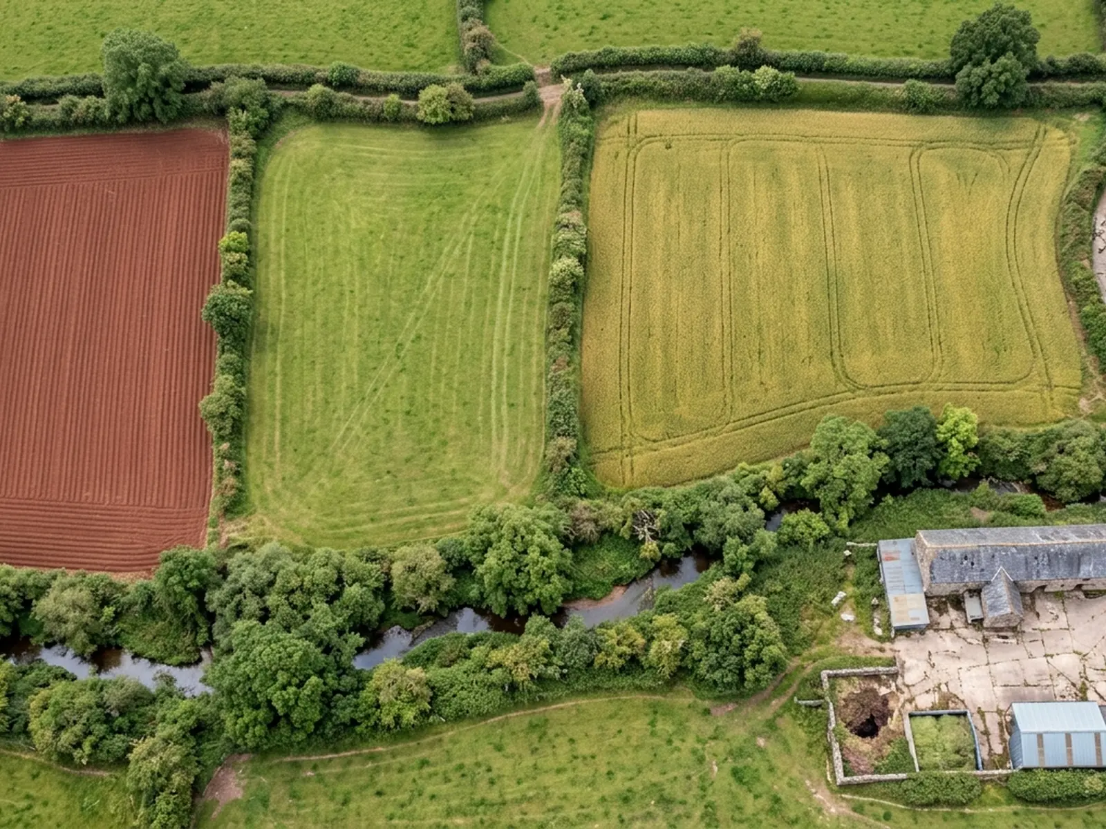
This is the standard job. The area is flown in a grid at a consistent height with heavy overlap between frames, and those frames are then stitched into a single square-on image of the whole parcel and built into a model of the surface underneath it.
What you do with it afterwards is the point. An orthomosaic can be measured across, unlike an oblique photograph, so boundaries, hard standing, tracks, ponds and building footprints can be picked off it. The surface model carries height, so slopes, banks, spoil and drainage falls come with it.
Farms and estates use it for management mapping and for grant and tenancy paperwork. Developers and groundworks contractors use it for a before-and-after record of a site. Solar and renewables developers use it to see a whole array and its access at once rather than in a hundred separate photographs.
What is included
- A flight plan drawn round your parcel before the price is agreed, not on the day
- A stitched orthomosaic of the whole area, square on, at the resolution the flight height allows
- A surface model of the ground and everything standing on it
- Contours generated from that surface model where you have asked for them
- A point cloud and a textured model where the job calls for one
- The original frames, so any detail can be traced back to the photograph it came from
- A written report inside 48 hours setting out what was flown and what the capture could not see
- A plain statement of where control was and was not available on the ground
Why overlap and height decide everything
A photogrammetric model is built by finding the same point on the ground in several photographs taken from different positions. That only works if the frames overlap heavily, which is why a survey grid looks so repetitive from the ground: the aircraft is flying the same field several times over on parallel lines.
Height sets the level of detail in the imagery, and it also sets how much ground a battery covers. Those two pull against each other on every job. A large parcel flown high gives you the whole holding in one image with less detail in it; the same parcel flown lower gives you finer detail and a longer visit. Which one you want depends on what you are going to do with the result, which is why the brief matters.
Surface model, not bare earth
What comes out of photogrammetry is a model of the visible surface. Where a field is bare or short-grazed, the surface and the ground are close to the same thing. Where there is standing crop, long grass, gorse or a tree canopy, they are not: the model follows the top of the vegetation, because that is what the camera can see.
Bare-earth models can be produced by filtering the surface, and that works reasonably on open ground with scattered cover. It does not work under a closed canopy, and no amount of processing invents ground the camera never saw. If the job needs levels under woodland, that is a job for airborne laser scanning rather than for a camera, and we will tell you so rather than sell you a filtered guess.
The practical answer on most farmland is timing. After harvest and before growth, the surface and the ground are close enough for most purposes, and a survey flown in that window is worth more than the same survey flown in June.
What an orthomosaic is not
It is not a plan drawn by a surveyor and it is not a legal boundary. It is a photograph of what was there on the day, corrected so it can be measured across. Hedges, banks, gates and tracks show as they actually are rather than as the deeds describe them, which is often the useful part, but a disputed boundary needs someone qualified to opine on it.
It is also a snapshot. Ground moves, crops change, stock poach a gateway over a winter. Where the comparison over time is the point, the answer is repeat flights at the same height on the same plan, which is the next service on this site.
On the day
How a site mapping runs
- Step 1
Boundary and output
You send a boundary, a postcode or a specification. We work out whether it is one flight, several batteries or two visits, and what height the airspace and the ground allow.
- Step 2
Fixed price
One price for the flight and the listed outputs, travel included. If part of your specification needs control set by a land surveyor, we say so before you commit rather than after.
- Step 3
Weather window
The date moves for wind, rain, low cloud or a sun angle that would fill the parcel with shadow. Moving it costs nothing; flying into it wastes the visit.
- Step 4
Capture
Take off from a point you control, then an automated grid with fixed line spacing and overlap. Anything on the ground that deserves a closer frame gets one before we pack up.
- Step 5
Processing and delivery
Frames are stitched and the outputs built in the formats agreed. Files arrive with the report, and the report says how the capture was flown.
Behind the work
Kit, cover and qualifications
Registered operator
CAA registered, with an Operator ID and a Flyer ID held. Both are checkable, and any land agent or consultant is welcome to ask for them before a flight is booked.
A2 Certificate of Competency
The A2 CofC, which is what governs how close the aircraft may work to people who are not part of the job. No GVC is held, so operations are planned inside the A2 CofC.
Aircraft
A DJI Mavic 4 Pro carrying a 100 megapixel Hasselblad camera and 6K video, and a DJI Mavic 2 Enterprise Advanced with a 640 by 512 radiometric thermal camera.
Insurance
Insured with Coverdrone for commercial operations. A certificate goes to your office before the visit if your site induction needs one on file.
Site mapping
Aerial site mapping questions
- Can you give me the files in the coordinate system we use?
- Tell us which one when you ask for the price. Outputs are produced in the system agreed at the start, and it is far easier to plan for that than to shift a finished model afterwards.
- How large a parcel is too large for one visit?
- There is no fixed line. It depends on the height the site allows, how broken the ground is, and how long the weather window holds. Send the boundary and you get a straight answer about whether it is one visit or two, in the quote rather than on the day.
- Do you need me on site while you fly?
- Not usually, as long as we have access, a take off point and a way of knowing that nobody else will walk into the working area. On a live construction site or somewhere with stock or public access, having someone from your side there makes the visit quicker.
Where
Aerial site mapping across the South West
Also on this site
Tell us the output you need
Request a quote with Aerial Survey
Send the boundary or the postcode and the output you need. Sam Hembury comes back with a fixed price, a date and anything in the brief that needs settling first.